

(Image rightclicked from www.pia.gov.ph i’m looking for a more detailed map and ideally i should animate an imaginary line connecting the tips of the outermost islands and islets, run it, and connect it around the archipelago.)
Malacañang representatives try to make this sound technical, convoluted, confused, and at the same time, threaten us that if Congress asserted our claim over certain territories (Kalayaan, Scarborough, and other islets), we have to go to war. (see the warning issued by the Commission on Maritime and Ocean Affairs under the Office of the President, presented to Congress this week, www.inquirer.net “Proposed baselines: War or Surrender”, Inquirer article, March 14, 2008)
Today, Malacañang through the Executive Secretary admitted (see www.inquirer.net ) that it was behind the move to bring back the House bill on archipelagic baselines to the committee level (wasting years of hearings, studies, and discussion, and precariously near the U.N. deadline); while the DFA undersecretary admitted that indeed China last December in an unofficial communication, protested the latest assertion of claim by the Philippines over the Kalayaan group of islands.
The DFA, the agency, next to the President herself, tasked to represent our interests in foreign relations, did not say what it did or how it answered the protest from China. Because they did not say anything, we should suppose they just nodded their heads then.
Contrary to how the Malacañang representatives make it appear in their justification, the conflict is not so technical or so complicated for our countrymen that we should all leave it up to the trustworthy Malacañang bureaucrats. It’s not technical and convoluted, it’s about our land — the outermost islets off the coast of Palawan are disputed, yes, but we never gave up our claims based on rights created by law: treaties and international conventions. (“off the coast” should probably not even be used anymore; the U.P. Law Center in a press conference showed studies of a continental shelf connecting the islets to Palawan)
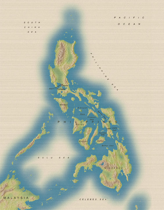
The Philippine archipelago — the classic definition of an archipelago is:
An archipelago is “a body of water studded with islands”. That definition is embedded in the consciousness of all Philippine lawyers because the way it is worded (it starts with the mass of water then says, “studded with islands”) is both striking and stunning. And it is meaningful because it’s our home and it’s who we are, we’re a group of 7,100 islands and islets, and a hundred languages and dialects and provinces separated by seas and oceans but one nation.
And so at the end of it all, after hundreds of millions of dollars in payoffs and witnesses disappearing, was it all about those territories, our land, our claim, our history?
The most important of the series of conflicts from January to March came to light at the end, and it was the most valuable.
Were those deals with China all about our territories?
Our rights and claims are based on law. Under the archipelagic doctrine under the U.N. Convention on the Law of the Sea, an archipelago is one unit determined by connecting the outermost islands and islets with an imaginary straight line; all bodies of land and waters inside the baseline form the entire archipelago.
The purpose of the archipelagic doctrine (i’m using Justice V.V. Mendoza’s notes; these are not mine) is to protect the territorial integrity of the archipelago. Without it, (according to Justice V.V.): there would be “pockets of high seas” between some of our islands and islets, as for instance between Bohol and Siquijor, thus foreign vessels would be able to pass through these “pockets of high seas” and we would have no jurisdiction over them. And so, in order to protect the land, the group of islands and the waters between them and all islets and shoal and rocks within the baseline are all considered one unit under the archipelagic doctrine under UNCLOS.
(Here’s a pre-UNCLOSmap, or a map that does not reflect UNCLOS):
[A pre-UNCLOS map, i think; or at least a map that does not reflect UNCLOS, note the “pocket of high sea” (the white part, Sulu Sea) inside the archipelago; or at least that’s how this map makes it look. Image rightclicked from www.navy.mil (an American site)]
Our rights are based not only on international law but also on treaties: (still using Justice V.V. Mendoza’s notes; these are not mine): The Treaty of Paris defining the metes and bounds of the archipelago; the Treaty of Washington between the U.S. and Spain in the 1900’s; ceding Cagayan, Sibuto, and Sulu; the Treaty between U.S. and Great Britain, 1930, ceding Turtle Island and Mangsi Island.
It is true that through the years, some of the islets that are part of the disputed territories, or some of the islets that fall inside the baseline, have been occupied by China and Vietnam. The Chief Executive, the Commander-in-Chief, speaking through her lieutenants and assistants, wants Congress to exclude those islets by drawing the baseline in such manner that those islets fall outside our baseline, thus Malacañang ordered its congressmen to bring back the House bill on baselines, already approved on second reading and up for approval on third reading, brought back to the committee level again.
It is true that we are a small country with a small military capability compared to China.
But we have never given up those claims, we have never recognized their occupation as evidence of ownership; international law does not recognize invasion or occupation as a source of right; we have not authorized our “leaders” to sell or cede any part of our claimed territories; those “leaders” are under question and scrutiny now for allegedly accepting bribes and commissions in hundreds of millions of dollars from Chinese corporate officials; we are not about to surrender any part of our land; the dispute over those territories should be resolved in the U.N. and in the meantime the Philippine legislature should be doing its job of defending our rigts, and those “leaders”, whether they are in Congress, the Supreme Court or in Malacañang selling our territories would be disowned, disavowed and driven away from our land. Maybe together with their foreign patrons. We have a history of doing that.
